Where does half of the United States' population live?

Half of the United States' population lives on just 0.8% of its land.

Measured from the GHSL population grid (European Commission JRC, 2025) inside Natural Earth borders. How we measured this

  • The north-east side: half the population, on 21.9% of the land
  • The rest: the other half, on 78.1%

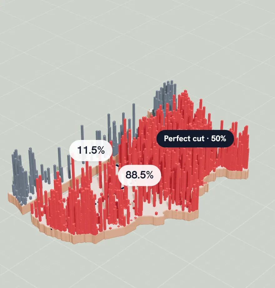
Taller columns mean more people. The dashed line is the most lopsided straight cut that still splits the population exactly in half. Data: GHSL population grid (European Commission JRC, 2025) inside Natural Earth borders.

The straight-line test

Draw one straight line across the United States so that exactly half the population is on each side. Of all the lines that do it, the most lopsided puts half of everyone on the north-east side, on just 21.9% of the land.

Now cut the land in half instead, at the same angle. That looks like the fair cut, but the north-east half ends up with 67.0% of the people. Both figures are our measurements from the GHSL population grid (European Commission JRC, 2025) inside Natural Earth borders.

That gap between how a country looks and where its people are is exactly what Slice is about.

Why America's population leans east

The United States has more than 3,000 counties, but half of all Americans live in just 145 of them, according to an analysis of Census Bureau estimates reported by Carolina Demography. The rest of the country, most of its land, holds the other half.

The weight sits in the east. If every American weighed the same, the country would balance on one point: the 2020 center of population, near Hartville, Missouri. The middle of the map itself, the geographic center of the lower 48, is near Lebanon, Kansas: hundreds of miles further west.

That point has moved almost 900 miles since the first census in 1790, and 2020's is the furthest west and south it has ever been. Even so, it is still in Missouri, as it has been for five censuses in a row.
Think you can do better? Try splitting the United States yourself.

Now you know where everyone lives, so this should be easy, right? In Slice you get one straight line to cut the United States' population exactly in half, and a second try if you need it. Then the country splits and the population rises in columns, to show how close you got.

Free, no sign-up. Practice never touches your daily score or streak.

The United States in Slice after a cut: the country split in two, its population rising in columns, with each side's share labelled.

How we measured this

Every figure on this page comes from the same data as the game: the GHSL population grid (European Commission JRC, 2025) inside Natural Earth borders, which estimates how many people live in each 1 km square. We draw the country on an equal-area map, so every square kilometre counts the same.

“0.8% of its land” counts the most crowded 1 km squares first, until they hold half the people. It measures how tightly people pack, which is why it comes out much smaller than maps that colour whole cities or counties. The straight-line figures test a cut at every angle, one degree apart. The map shows the lower 48 states: Alaska and Hawaii are left out, as they are in the game.

Sources